

Following the magnitude 7.5 earthquake in PNG in February 2018, AEES provided some funding for an aftershock monitoring mission, where two AEES members, Gary Gibson and Kevin McCue, travelled to PNG and installed 6 strong motion instruments in the region around the main shock’s epicentre. Read more about this here and here.
AEES allocated funds to cover the return flights to deploy and recover the instruments over a 2 month period, and also paid for the hire of two Gecko seismographs (data loggers) for that period. The Seismology Research Centre (SRC) provided 3 additional Gecko seismographs, and the University of Melbourne (UniMelb) provided one further Gecko seismograph along with six Guralp 5TC accelerometers (sensors).
The SRC and UniMelb provided the equipment for these 6 stations to remain in PNG for a further two months. Three of the stations were removed on a second data recovery trip in June 2018, and the remaining three UniMelb/SRC stations continue to operate in PNG. Data was again collected on a third data recovery trip in August 2019, with UniMelb leaving an additional set of equipment to be installed at a new station to the west of the existing network.
The seismographs were set to record data continuously at 200sps (samples per second) which has been collated and placed on the public AEES Google Drive, available for anyone to download. Data from the first deployment (19 March to 25 April, 2018) is available in the Year > Month > Day folder hierarchy. Within each day folder are one-hour-long zip files from each station (named PH01 to PH06), so most days have 144 zip files.
Data from the second and third data recovery trips are being collated and will be posted to the AEES Drive as it becomes available, pending available storage (10GB of 15GB used so far).
The zip files each contain 60 one-minute-long MiniSEED files, along with a text file containing station information. The generic sensitivity of these stations is 466186 (i.e. divide recorder counts by this value to calculate ground motion in m/s²). Use your preferred data analysis tools, or you can view the waveforms using the free Waves viewer. You can also export merged data from Waves to other formats including PC-SUDS, MiniSEED, and CSV.
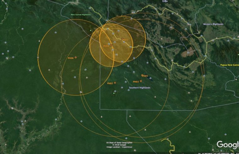
At the “year” level of the AEES Drive you’ll also find the merged data from the M6.3 aftershock from 2018-04-07 as a PC-SUDS format file, along with a Google Earth file that shows the station locations and some rough S-minus-P circles – this file is made by saving from Waves as a KML file.